Learn Coding Visually
Learn to code with interactive, live-preview playgrounds — HTML, CSS, JavaScript, React & more.
 HTML Playground42 lessons · Click-based · Live preview
 CSS PlaygroundLearn CSS with a live editor
 JavaScript Playground60 lessons · DOM · Async · Canvas
 React PlaygroundLearn React with a live code editor
 GSAP PlaygroundLearn GSAP animation interactively
 SVG Playground44 lessons · shapes · paths · animation
 SCSS Playground45 lessons · Sass modules · tokens
 Tailwind PlaygroundLearn Tailwind CSS with a live editor
 Bootstrap 5 Playground50 lessons · live preview
Location & Address Card — Map Pin HTML CSS Snippet
Location & Address Card · Cards · Plain HTML, CSS & JS · Live preview
What's included
Features
About this UI Snippet
Location & Address Card — CSS-Drawn Map, Animated Pin Drop & Directions Actions
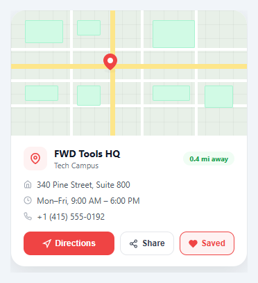
A location card presents an address in a visually rich format — more engaging than plain text, less complex than a full embedded map. It combines a decorative map background, a prominent pin marker, structured address details, and action buttons for directions, sharing, and saving. This pattern is common on restaurant pages, contact pages, event listings, and store finder tools.
CSS-drawn map background
The map is rendered entirely in CSS without any map SDK or external tiles. The technique layers three elements: a grid background using background-image: linear-gradient repeating at 20px intervals for the map grid lines; absolutely-positioned .road divs (horizontal and vertical, with a thicker yellow variant for main roads); and .block divs representing buildings with a light green fill. This produces a convincing simplified map aesthetic that is lightweight, privacy-friendly (no Google Maps API key needed), and fully customisable.
Pin drop animation
The map pin uses @keyframes pinDrop: the pin starts 20px above its final position with opacity 0, then drops into place over 0.5s with an ease curve after a 0.3s delay (allowing the card to render before the pin draws attention). A separate @keyframes shadow animates a small elliptical shadow below the pin, scaling and fading in sync with a bouncing motion to sell the depth illusion.
Distance badge
A green pill badge showing "0.4 mi away" sits in the top-right of the info panel. In production, this would be calculated from the user's geolocation using the Haversine formula: Math.acos(sin(lat1)*sin(lat2) + cos(lat1)*cos(lat2)*cos(lon2-lon1)) * 6371. The badge uses semantic green colouring (#f0fdf4 background, #16a34a text) to reinforce "close = good".
Address block structure
The address uses the HTML <address> element (semantically correct for contact information) styled as a flex column. Each .addr-line pairs a small SVG icon with its text using display:flex; gap:7px. The icons (home, clock, phone) provide at-a-glance parsing of address vs. hours vs. phone number — users can scan to the icon they need rather than reading each line.
Save button toggle state
The save button toggles between save and saved states. In the saved state, the .saved class adds a red border and background (#fef2f2), and the SVG heart fill changes to red by setting the fill attribute in JavaScript. The text changes from "Save" to "Saved" via innerHTML string replacement. In production, persist saved state to localStorage so it survives page refresh.
React integration
Accept props: name, type, address, hours, phone, lat, lng, distance. Calculate pin position from lat/lng relative to a bounding box. Use useState(false) for saved state. The directions button opens https://www.google.com/maps/dir/?api=1&destination=${encodeURIComponent(address)} in a new tab.
See also the event card snippet for cards with date and venue, the profile card snippet for person-based cards, and the sticky promo bar snippet for location-aware banners.
Build with AI
Build, Understand, Optimize, and Extend It With AI
You do not need to piece together how the fake map reads as a map purely from the CSS. Paste this snippet's HTML, CSS, and JS into an AI coding assistant like Claude and ask it to explain exactly how the layered .map-grid background-image, the absolutely positioned .road divs, and the .block divs combine with the pinDrop and shadow keyframes to sell a believable simplified map with zero image requests. The same assistant can help optimize it, for instance asking whether the distance-pill value should be computed live from navigator.geolocation and the Haversine formula instead of being hardcoded, and where that calculation belongs in the load sequence. It is also useful for extending the card: ask it to wire the Share button to the real Web Share API with a clipboard fallback, persist the Save toggle to localStorage so it survives a refresh, or swap the CSS map for a real embedded map iframe while keeping the pin-drop animation on top of it. Treat the code less like a finished artifact and more like a starting point for a conversation.
Prompt to recreate it
Copy this into your AI assistant of choice to build the effect from scratch, or as a jumping-off point for your own variant:
Build a "location and address card" in plain HTML, CSS, and JavaScript with no map SDK, no API key, and no external map tiles — the map itself must be drawn entirely from CSS.

Requirements:
- A map area built only from stacked divs: a repeating grid-line background using a CSS linear-gradient background-image at a fixed pixel interval, several absolutely positioned "road" strips (both horizontal and vertical, with at least one thicker "main road" variant in a different color), and several absolutely positioned rectangular "building block" divs with a light fill and border.
- A pin marker centered over the map, built from an SVG teardrop shape, that animates in on load with a keyframe dropping it from above into place with a fade-in, plus a separate small elliptical shadow beneath it that continuously scales and fades in a loop to sell depth.
- An info panel below the map containing: a location name and type, a distance pill badge, and a semantic HTML address element with three lines (street address, hours, phone), each line pairing a small inline SVG icon with its text.
- Three action buttons — Directions, Share, and Save — where clicking Directions temporarily swaps its icon and label to an "Opening..." confirmation before reverting, clicking Share swaps to a "Copied!" confirmation with a temporary color change before reverting, and clicking Save toggles a persistent saved visual state (changed border, background, and filled heart/save icon) that stays active until clicked again.
- The Save button's toggled state must be reflected in both a CSS class and the icon's fill attribute, and the button's visible text must swap between "Save" and "Saved" using simple string replacement on its own innerHTML.
Want to tighten it up first? Run this prompt through the AI Prompt Studio to score it across 8 quality dimensions, catch anti-patterns, and tune the wording for Claude, ChatGPT, or Gemini before you paste it in.
Source Code
<div class="demo">
  <div class="lcard">
    <!-- Map background with CSS grid pattern -->
    <div class="map-area">
      <div class="map-grid"></div>
      <div class="map-roads">
        <div class="road road-h" style="top:30%"></div>
        <div class="road road-h" style="top:55%"></div>
        <div class="road road-h" style="top:75%"></div>
        <div class="road road-v" style="left:25%"></div>
        <div class="road road-v" style="left:55%"></div>
        <div class="road road-v" style="left:78%"></div>
        <div class="road road-h road-main" style="top:43%"></div>
        <div class="road road-v road-main" style="left:42%"></div>
      </div>
      <div class="map-blocks">
        <div class="block" style="top:8%;left:6%;width:16%;height:18%"></div>
        <div class="block" style="top:8%;left:28%;width:10%;height:12%"></div>
        <div class="block" style="top:8%;left:60%;width:18%;height:22%"></div>
        <div class="block" style="top:60%;left:6%;width:14%;height:12%"></div>
        <div class="block" style="top:60%;left:28%;width:10%;height:16%"></div>
        <div class="block" style="top:60%;left:60%;width:16%;height:12%"></div>
        <div class="block" style="top:60%;left:82%;width:12%;height:18%"></div>
      </div>
      <div class="map-pin">
        <div class="pin-drop">
          <svg width="20" height="24" viewBox="0 0 20 24" fill="none">
            <path d="M10 0C4.48 0 0 4.48 0 10c0 7.5 10 14 10 14s10-6.5 10-14c0-5.52-4.48-10-10-10z" fill="#ef4444"/>
            <circle cx="10" cy="10" r="4" fill="#fff"/>
          </svg>
        </div>
        <div class="pin-pulse"></div>
      </div>
    </div>

    <!-- Info panel -->
    <div class="info-panel">
      <div class="info-top">
        <div class="location-icon">
          <svg width="16" height="16" viewBox="0 0 24 24" fill="none" stroke="currentColor" stroke-width="2.5" stroke-linecap="round"><path d="M21 10c0 7-9 13-9 13s-9-6-9-13a9 9 0 0 1 18 0z"/><circle cx="12" cy="10" r="3"/></svg>
        </div>
        <div class="location-meta">
          <div class="location-name">FWD Tools HQ</div>
          <div class="location-type">Tech Campus</div>
        </div>
        <div class="distance-pill">0.4 mi away</div>
      </div>

      <address class="address-block">
        <div class="addr-line">
          <svg width="12" height="12" viewBox="0 0 24 24" fill="none" stroke="currentColor" stroke-width="2" stroke-linecap="round"><path d="M3 9l9-7 9 7v11a2 2 0 0 1-2 2H5a2 2 0 0 1-2-2z"/><polyline points="9 22 9 12 15 12 15 22"/></svg>
          340 Pine Street, Suite 800
        </div>
        <div class="addr-line">
          <svg width="12" height="12" viewBox="0 0 24 24" fill="none" stroke="currentColor" stroke-width="2" stroke-linecap="round"><circle cx="12" cy="12" r="10"/><polyline points="12 6 12 12 16 14"/></svg>
          Mon–Fri, 9:00 AM – 6:00 PM
        </div>
        <div class="addr-line">
          <svg width="12" height="12" viewBox="0 0 24 24" fill="none" stroke="currentColor" stroke-width="2" stroke-linecap="round"><path d="M22 16.92v3a2 2 0 0 1-2.18 2 19.79 19.79 0 0 1-8.63-3.07 19.5 19.5 0 0 1-6-6 19.79 19.79 0 0 1-3.07-8.67A2 2 0 0 1 4.11 2h3a2 2 0 0 1 2 1.72c.127.96.361 1.903.7 2.81a2 2 0 0 1-.45 2.11L8.09 9.91a16 16 0 0 0 6 6l1.27-1.27a2 2 0 0 1 2.11-.45c.907.339 1.85.573 2.81.7A2 2 0 0 1 22 16.92z"/></svg>
          +1 (415) 555-0192
        </div>
      </address>

      <div class="action-row">
        <button class="btn-dir" onclick="handleDir()">
          <svg width="13" height="13" viewBox="0 0 24 24" fill="none" stroke="currentColor" stroke-width="2.5" stroke-linecap="round"><polygon points="3 11 22 2 13 21 11 13 3 11"/></svg>
          Directions
        </button>
        <button class="btn-share" onclick="handleShare()">
          <svg width="13" height="13" viewBox="0 0 24 24" fill="none" stroke="currentColor" stroke-width="2" stroke-linecap="round"><circle cx="18" cy="5" r="3"/><circle cx="6" cy="12" r="3"/><circle cx="18" cy="19" r="3"/><line x1="8.59" y1="13.51" x2="15.42" y2="17.49"/><line x1="15.41" y1="6.51" x2="8.59" y2="10.49"/></svg>
          Share
        </button>
        <button class="btn-save" id="saveBtn" onclick="handleSave()">
          <svg width="13" height="13" viewBox="0 0 24 24" fill="none" stroke="currentColor" stroke-width="2" stroke-linecap="round"><path d="M20.84 4.61a5.5 5.5 0 0 0-7.78 0L12 5.67l-1.06-1.06a5.5 5.5 0 0 0-7.78 7.78l1.06 1.06L12 21.23l7.78-7.78 1.06-1.06a5.5 5.5 0 0 0 0-7.78z"/></svg>
          Save
        </button>
      </div>
    </div>
  </div>
</div>
* { box-sizing: border-box; margin: 0; padding: 0; }
body { font-family: system-ui, sans-serif; background: #f1f5f9; display: flex; align-items: center; justify-content: center; min-height: 100vh; padding: 20px; }
.demo { width: 100%; max-width: 340px; }
.lcard { background: #fff; border-radius: 20px; box-shadow: 0 8px 32px rgba(0,0,0,0.1); overflow: hidden; }
/* Map */
.map-area { position: relative; height: 180px; background: #e8f0e8; overflow: hidden; }
.map-grid { position: absolute; inset: 0; background-image: linear-gradient(rgba(0,0,0,0.04) 1px,transparent 1px),linear-gradient(90deg,rgba(0,0,0,0.04) 1px,transparent 1px); background-size: 20px 20px; }
.map-roads { position: absolute; inset: 0; }
.road { position: absolute; background: #fff; }
.road-h { left: 0; right: 0; height: 4px; }
.road-v { top: 0; bottom: 0; width: 4px; }
.road-main { background: #fde68a; }
.road-h.road-main { height: 7px; }
.road-v.road-main { width: 7px; }
.map-blocks { position: absolute; inset: 0; }
.block { position: absolute; background: #d1fae5; border-radius: 2px; border: 1px solid #a7f3d0; }
.map-pin { position: absolute; top: 42%; left: 42%; transform: translate(-50%,-50%); z-index: 5; }
.pin-drop { animation: pinDrop 0.5s ease 0.3s both; }
@keyframes pinDrop { from { transform: translateY(-20px); opacity:0; } to { transform: none; opacity:1; } }
.pin-pulse { position: absolute; bottom: 0; left: 50%; transform: translateX(-50%); width: 20px; height: 6px; background: rgba(0,0,0,0.15); border-radius: 50%; animation: shadow 2s ease-in-out infinite; }
@keyframes shadow { 0%,100%{transform:translateX(-50%) scale(1);opacity:0.3} 50%{transform:translateX(-50%) scale(0.8);opacity:0.15} }
/* Info panel */
.info-panel { padding: 16px 18px; }
.info-top { display: flex; align-items: center; gap: 10px; margin-bottom: 12px; }
.location-icon { width: 34px; height: 34px; border-radius: 10px; background: #fef2f2; color: #ef4444; display: flex; align-items: center; justify-content: center; flex-shrink: 0; }
.location-meta { flex: 1; }
.location-name { font-size: 14px; font-weight: 700; color: #111827; }
.location-type { font-size: 11px; color: #6b7280; }
.distance-pill { font-size: 10px; font-weight: 700; background: #f0fdf4; color: #16a34a; padding: 3px 9px; border-radius: 20px; flex-shrink: 0; }
.address-block { font-style: normal; display: flex; flex-direction: column; gap: 7px; margin-bottom: 14px; }
.addr-line { display: flex; align-items: center; gap: 7px; font-size: 12px; color: #4b5563; }
.addr-line svg { color: #9ca3af; flex-shrink: 0; }
.action-row { display: flex; gap: 8px; }
.btn-dir { flex: 1; display: flex; align-items: center; justify-content: center; gap: 5px; padding: 9px 0; background: #ef4444; color: #fff; border: none; border-radius: 10px; font-size: 12px; font-weight: 700; cursor: pointer; transition: background 0.15s; }
.btn-dir:hover { background: #dc2626; }
.btn-share, .btn-save { display: flex; align-items: center; justify-content: center; gap: 5px; padding: 9px 12px; border: 1.5px solid #e5e7eb; border-radius: 10px; background: #fff; color: #374151; font-size: 12px; font-weight: 600; cursor: pointer; transition: all 0.15s; }
.btn-share:hover { border-color: #6366f1; color: #6366f1; }
.btn-save:hover { border-color: #ef4444; color: #ef4444; }
.btn-save.saved { background: #fef2f2; border-color: #ef4444; color: #ef4444; }function handleDir() {
const addr = '340+Pine+Street+Suite+800';
window._demoAction = 'Opening directions for ' + addr;
const btn = document.querySelector('.btn-dir');
const orig = btn.innerHTML;
btn.innerHTML = '<svg width="13" height="13" viewBox="0 0 24 24" fill="none" stroke="currentColor" stroke-width="2.5" stroke-linecap="round"><polyline points="20 6 9 17 4 12"/></svg> Opening...';
setTimeout(() => { btn.innerHTML = orig; }, 1500);
}
function handleShare() {
const btn = document.querySelector('.btn-share');
const orig = btn.innerHTML;
btn.innerHTML = '<svg width="13" height="13" viewBox="0 0 24 24" fill="none" stroke="currentColor" stroke-width="2.5" stroke-linecap="round"><polyline points="20 6 9 17 4 12"/></svg> Copied!';
btn.style.borderColor = '#6366f1';
btn.style.color = '#6366f1';
setTimeout(() => { btn.innerHTML = orig; btn.style.borderColor = ''; btn.style.color = ''; }, 1800);
}
let saved = false;
function handleSave() {
saved = !saved;
const btn = document.getElementById('saveBtn');
if (saved) {
btn.classList.add('saved');
btn.querySelector('svg').setAttribute('fill','#ef4444');
btn.innerHTML = btn.innerHTML.replace('Save','Saved');
} else {
btn.classList.remove('saved');
btn.querySelector('svg').setAttribute('fill','none');
btn.innerHTML = btn.innerHTML.replace('Saved','Save');
}
}Step by step
How to Use
- 1Copy the HTML structureThe card has two main sections: .map-area (CSS map background with pin) and .info-panel (address details and action buttons). Both are required.
- 2Update location detailsChange .location-name, .location-type, .distance-pill, and the three .addr-line texts for address, hours, and phone number.
- 3Add the CSSPaste the CSS block. The map colours (road yellow, building green, grid gray) can be customised by changing the colour values in .road-main, .block, and .map-grid.
- 4Wire up the directions buttonIn handleDir(), replace the demo action with window.open("https://www.google.com/maps/dir/?api=1&destination=" + encodeURIComponent(yourAddress), "_blank").
- 5Persist saved stateIn handleSave(), read/write to localStorage: localStorage.setItem("saved_location_X", saved) to remember the saved state across page loads.
Real-world uses
Common Use Cases
Got questions?
Frequently Asked Questions
Accept name, address, hours, phone, and distance props. Use useState for saved state. In the directions handler, open a Google Maps URL with the encoded address.
Replace .map-area contents with an <iframe src="https://www.google.com/maps/embed?pb=..."> set to 100% width and 180px height. Remove the CSS map styling.
Use navigator.geolocation.getCurrentPosition() to get user coords, then apply the Haversine formula against your location lat/lng. Update the distance-pill text with the result.
Yes — render multiple location cards in a grid or list. Highlight the nearest one (shortest distance) with a featured/active border style.
Open the Export menu (or the Test Exports preview) in the snippet toolbar. It generates a plain React component, a React + Tailwind version where the card, map, distance-badge, and button styles become utility classes, a Vue 3 single-file component, and an Angular standalone component. Each converter preserves the CSS-drawn map, the pin-drop and shadow animations, and the save/share button behaviour, so the card renders identically across React, Vue, and Angular. Pass name, type, address, hours, phone, lat, lng, and distance in as component props or inputs instead of hardcoding them in the markup, and keep the saved state in component state.
Replace the "Copied!" clipboard demo with the Web Share API: call navigator.share({ title: name, text: address, url: location.href }) inside the share handler, guarded by an if (navigator.share) check so it only runs where supported. On desktop browsers that lack it, fall back to navigator.clipboard.writeText() to copy the address and show the existing "Copied!" confirmation, so every user gets a working share action.
The card uses a fixed max-width, so on narrow viewports wrap it in a container with width: 100% and a max-width media query. Reduce the .map-area height (for example from 180px to 130px below 480px), let the three action buttons wrap with flex-wrap, and shrink the address font slightly so the info panel stays readable on phones without horizontal scrolling.
Wrap the card in JSON-LD using the LocalBusiness or Place schema with name, address (as a PostalAddress), telephone, openingHours, and geo (latitude and longitude) properties inside a <script type="application/ld+json"> tag. Search engines can then surface the address, hours, and a map pin directly in rich results — especially valuable on restaurant, store-finder, and event pages where local discovery drives most of the traffic.